Geolocate

Cleves topographic map

Click on the map to display elevation.

About this map
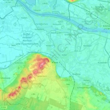
Name: Cleves topographic map, elevation, terrain.

Location: Cleves, Bedburg-Hau, Kreis Kleve, North Rhine-Westphalia, 47533, Germany (51.73187 6.03684 51.86545 6.24491)

Average elevation: 24 m

Minimum elevation: 7 m

Maximum elevation: 101 m

Other topographic maps

Click on a map to view its topography, its elevation and its terrain.
Keeken

Germany > North Rhine-Westphalia > Kreis Kleve > Cleves

Average elevation: 13 m

Rindern

Germany > North Rhine-Westphalia > Kreis Kleve > Cleves

Average elevation: 21 m

Empel

Germany > North Rhine-Westphalia > Kreis Kleve > Rees

Average elevation: 18 m

Asperden

Germany > North Rhine-Westphalia > Kreis Kleve > Goch

Average elevation: 18 m

Vorselaer

Germany > North Rhine-Westphalia > Kreis Kleve > Weeze

Average elevation: 20 m

Gear up for your next adventure:

🧥Packable Down Jackets - Lightweight warmth that compresses small in your bag
🗺️Scratch-off Peak Maps - Track your progress climbing Munros or Wainwrights
🧼Technical Clothing Wash - Special soap to clean and restore waterproof membranes
🥤Hiking Water Bottles - Reusable bottles for hydration on the trail
👕Technical Hiking Tees - Moisture-management for high-exertion climbs

As an Amazon Associate, this site earns from qualifying purchases at no extra cost to you.