
Baiersbronn topographic map
Interactive map
Click on the map to display elevation.
About this map
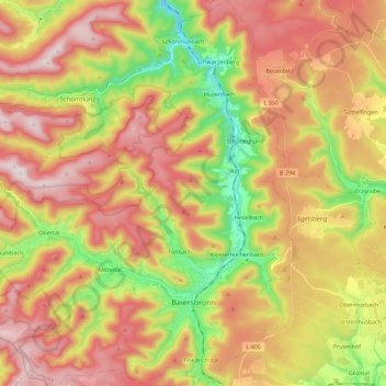
Name: Baiersbronn topographic map, elevation, terrain.
Average elevation: 735 m
Minimum elevation: 449 m
Maximum elevation: 993 m
Other topographic maps
Click on a map to view its topography, its elevation and its terrain.
Bad Rippoldsau
Germany > Baden-Württemberg > Landkreis Freudenstadt > Bad Rippoldsau-Schapbach
Bad Rippoldsau, Bad Rippoldsau-Schapbach, Vereinbarte Verwaltungsgemeinschaft Freudenstadt, Landkreis Freudenstadt, Baden-Württemberg, 77776, Germany
Average elevation: 716 m