Geolocate

Balod topographic map

Click on the map to display elevation.

Balod

Balod is located at 20°44′N 81°12′E / 20.73°N 81.2°E / 20.73; 81.2. It has an average elevation of 324 metres (1063 feet).

Wikipedia (CC-BY-SA 3.0)

About this map

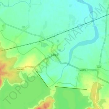
Name: Balod topographic map, elevation, terrain.

Location: Balod, Balod Tahsil, Balod, Chhattisgarh, 491226, India (20.68720 81.16542 20.76720 81.24542)

Average elevation: 323 m

Minimum elevation: 306 m

Maximum elevation: 363 m

Gear up for your next adventure:

🧢Hiking Hats - Sun and weather protection for outdoor walks
🌄Compact Monoculars - Lightweight optics for hiking
🎒Hiking Daypacks (20L) - Compact backpacks for day trips and technical mountain ascents
📱Phone Mounts for Hiking - Secure mounts to carry your phone on trails
🧭Emergency Beacons - Safety beacons for remote outdoor locations

As an Amazon Associate, this site earns from qualifying purchases at no extra cost to you.