Geolocate

Conroe topographic map

Click on the map to display elevation.

About this map

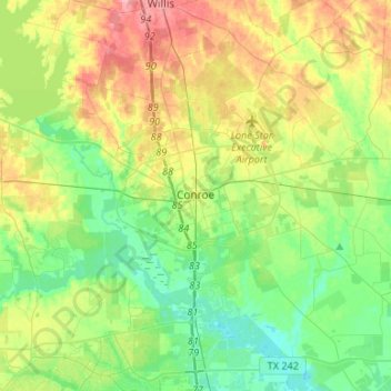
Name: Conroe topographic map, elevation, terrain.

Location: Conroe, Montgomery County, Texas, United States (30.20266 -95.65670 30.41999 -95.39094)

Average elevation: 62 m

Minimum elevation: 27 m

Maximum elevation: 123 m

Other topographic maps

Click on a map to view its topography, its elevation and its terrain.

Bobville

United States > Texas > Montgomery County

Average elevation: 75 m

Mount Zion

United States > Texas > Montgomery County

Average elevation: 88 m

New Caney

United States > Texas > Montgomery County

Average elevation: 30 m

Security

United States > Texas > Montgomery County

Average elevation: 53 m

Conroe

United States > Texas > Montgomery County > Conroe > Conroe

Average elevation: 60 m

Porter

United States > Texas > Montgomery County

Average elevation: 30 m

Lake Egypt

United States > Texas > Montgomery County > Egypt

Average elevation: 61 m

New Caney

United States > Texas > Montgomery County

Average elevation: 30 m

Gear up for your next adventure:

🛌Sleeping Bags - Warm and packable sleeping bags for outdoor nights
🥼Base Layers - Thermal base layers for temperature regulation
🎒Replacement Sternum Straps - Repair parts for hiking rucksacks
🥤Collapsible Water Bottles - Save space in your rucksack as you consume your water
🥤Hiking Water Bottles - Reusable bottles for hydration on the trail

As an Amazon Associate, this site earns from qualifying purchases at no extra cost to you.