
Thank you for supporting this site ❤️
Make a donation
Make a donation
Gear up for your next adventure:
As an Amazon Associate, this site earns from qualifying purchases at no extra cost to you.
Sainte-Marie topographic map
Click on the map to display elevation.
Thank you for supporting this site ❤️
Make a donation
Make a donation
Gear up for your next adventure:
As an Amazon Associate, this site earns from qualifying purchases at no extra cost to you.
About this map
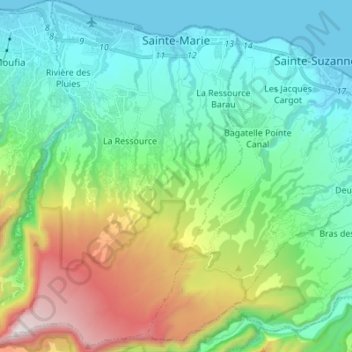
Name: Sainte-Marie topographic map, elevation, terrain.
Location: Sainte-Marie, Saint-Denis, Réunion, 97438, France (-21.01025 55.46916 -20.88233 55.57775)
Average elevation: 473 m
Minimum elevation: 0 m
Maximum elevation: 1,795 m
Thank you for supporting this site ❤️
Make a donation
Make a donation
Gear up for your next adventure:
As an Amazon Associate, this site earns from qualifying purchases at no extra cost to you.