Geolocate

Orlando Loch Haven Park topographic map

Click on the map to display elevation.

About this map
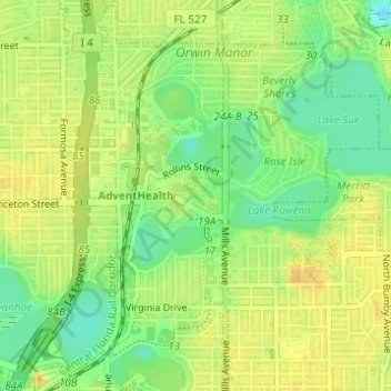
Name: Orlando Loch Haven Park topographic map, elevation, terrain.

Location: Orlando Loch Haven Park, Orlando, Orange County, Florida, United States (28.56933 -81.37134 28.57418 -81.36458)

Average elevation: 31 m

Minimum elevation: 14 m

Maximum elevation: 43 m

Other topographic maps

Click on a map to view its topography, its elevation and its terrain.

Lake Arnold

United States > Florida > Orange County > Orlando

Average elevation: 37 m

Lake Gear

United States > Florida > Orange County > Orlando

Average elevation: 35 m

Lake Mann

United States > Florida > Orange County > Orlando

Average elevation: 31 m

Lake Tennessee

United States > Florida > Orange County > Orlando

Average elevation: 36 m

Lake Emerald

United States > Florida > Orange County > Orlando

Average elevation: 33 m

Newport Park

United States > Florida > Orange County > Orlando

Average elevation: 27 m

Gear up for your next adventure:

🐕Hiking Dog Harnesses - Rugged harnesses for taking your companion on mountain trails
🧺Mesh Stuff Sacks - Breathable storage for wet gear or camp organization
🧥Breathable Waterproof Jackets - Essential rain protection for the unpredictable British climate
🔋Lithium AA Batteries - Long-lasting power that performs well in cold mountain weather
🥾Men's Waterproof Hiking Boots - Durable footwear with deep lugs for muddy and rocky UK terrains

As an Amazon Associate, this site earns from qualifying purchases at no extra cost to you.