Geolocate

Ravenna topographic map

Click on the map to display elevation.

About this map

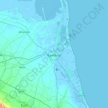
Name: Ravenna topographic map, elevation, terrain.

Location: Ravenna, Emilia-Romagna, 48121-48125, Italy (44.21314 12.02900 44.62834 12.34810)

Average elevation: 4 m

Minimum elevation: -9 m

Maximum elevation: 194 m

Other topographic maps

Click on a map to view its topography, its elevation and its terrain.

Castel Raniero

Italy > Emilia-Romagna > Ravenna > Faenza > Errano

Average elevation: 95 m

Marina Romea

Italy > Emilia-Romagna > Ravenna > Ravenna

Average elevation: 0 m

Campanile

Italy > Emilia-Romagna > Ravenna > Lugo

Average elevation: 7 m

Rocca di Riolo

Italy > Emilia-Romagna > Ravenna > Riolo Terme > Poggiolino

Average elevation: 118 m

Gear up for your next adventure:

📱Phone Mounts for Hiking - Secure mounts to carry your phone on trails
🧊Personal Water Filters - Drink safely from mountain streams marked on your map
🧣Neck Gaiters - Versatile protection against wind and cold
🧢Thermal Beanie Hats - Prevent heat loss from the head in windy summit conditions
👟Heavy Duty Boot Laces - Always carry a spare for your hiking footwear

As an Amazon Associate, this site earns from qualifying purchases at no extra cost to you.