Geolocate

Cabcaben topographic map

Click on the map to display elevation.

About this map

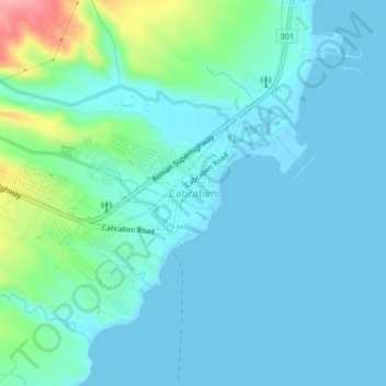
Name: Cabcaben topographic map, elevation, terrain.

Location: Cabcaben, Mariveles, Bataan, Central Luzon, Philippines (14.43446 120.57108 14.47446 120.61108)

Average elevation: 21 m

Minimum elevation: -1 m

Maximum elevation: 125 m

Other topographic maps

Click on a map to view its topography, its elevation and its terrain.

Laki Beach

Philippines > Bataan > Mariveles

Average elevation: 30 m

Laki Beach

Philippines > Bataan > Mariveles

Average elevation: 30 m

Gear up for your next adventure:

🧭Orienteering Compasses - Accurate compasses for map-based navigation
🛌Sleeping Bags - Warm and packable sleeping bags for outdoor nights
🧣Neck Gaiters - Protects against wind and sun on exposed ridges and peaks
🚲Bikepacking Frame Bags - Storage for tools and navigation gear on long off-road rides
👟Heavy Duty Boot Laces - Always carry a spare for your hiking footwear

As an Amazon Associate, this site earns from qualifying purchases at no extra cost to you.