
Salento topographic map
Interactive map
Click on the map to display elevation.
About this map
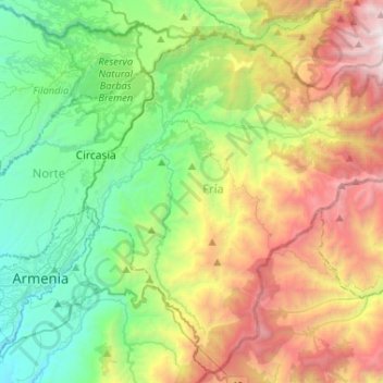
Name: Salento topographic map, elevation, terrain.
Location: Salento, Fría, Quindío, RAP Eje Cafetero, Colombia (4.47274 -75.64283 4.71653 -75.38269)
Average elevation: 2,335 m
Minimum elevation: 1,288 m
Maximum elevation: 4,288 m
The town of Salento itself lies on a plateau above the Quindío river valley. The section of the river valley from Salento to the head of the river is known as the Cocora valley. The town is located at an average altitude of 1895 meters above sea level, with steep drops to the valley floor at its northern and western perimeters.
Other topographic maps
Click on a map to view its topography, its elevation and its terrain.
Valle del Cocora - Palma de Cera
Valle del Cocora - Palma de Cera, Cocora, Salento, Fría, Quindío, RAP Eje Cafetero, Colombia
Average elevation: 2,623 m
Perímetro Urbano Armenia
Perímetro Urbano Armenia, Armenia, Capital, Quindío, RAP Eje Cafetero, Colombia
Average elevation: 1,481 m
Comuna Quimbaya
Colombia > Quindío > Comuna Quimbaya
Comuna Quimbaya, Armenia, Quindío, Colombia
Average elevation: 1,549 m