
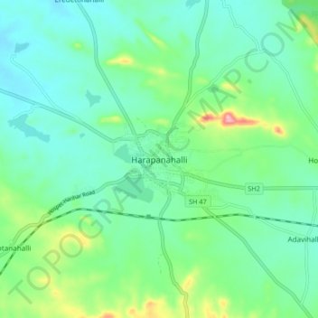
Harapanahalli topographic map
Interactive map
Click on the map to display elevation.
About this map
Name: Harapanahalli topographic map, elevation, terrain.
Average elevation: 626 m
Minimum elevation: 584 m
Maximum elevation: 757 m
It has an average elevation of 633 metres (2076 feet) away from the sea level. Harapanahalli is surrounded by several districts like Davanagere in the South, Chithradurga in the Southeast, Haveri in the West. Harapanahalli had operated under Bellari, Davanagere districts and Now it is operating under Vijayanagara District.
Other topographic maps
Click on a map to view its topography, its elevation and its terrain.
Arasikeri
India > Karnataka > Harapanahalli taluku
Arasikeri, Harapanahalli taluku, Vijayanagara district, Karnataka, India
Average elevation: 608 m