
Skye topographic map
Interactive map
Click on the map to display elevation.
About this map
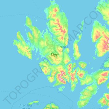
Name: Skye topographic map, elevation, terrain.
Location: Skye, Highland, Scotland, United Kingdom (57.01782 -6.78982 57.70824 -5.64758)
Average elevation: 63 m
Minimum elevation: 0 m
Maximum elevation: 918 m
Beyond Loch Snizort to the west of Trotternish is the Waternish peninsula, which ends in Ardmore Point's double rock arch. Duirinish peninsula is separated from Waternish by Loch Dunvegan, which contains the island of Isay. It is ringed by sea cliffs that reach 296 metres (971 feet) on the west at Waterstein Head and on the northwest at Biod an Athair where, a metre from the summit trig pillar, the cliffs drop 1,029 feet (314 metres) to the ocean. Oolitic loam provides good arable land in the main valley. Lochs Bracadale and Harport and the island of Wiay lie between Duirinish and Minginish, which includes the narrower defiles of Talisker and Glen Brittle and whose beaches are formed from black basaltic sands. Strathaird is a relatively small peninsula close to the Cuillin hills with only a few crofting communities, the island of Soay lies offshore. The bedrock of Sleat in the south is Torridonian sandstone, which produces poor soils and boggy ground, although its lower elevations and relatively sheltered eastern shores enable a lush growth of hedgerows and crops. The islands of Raasay, Rona, Scalpay and Pabay all lie to the north and east between Skye and the mainland.
Other topographic maps
Click on a map to view its topography, its elevation and its terrain.
Fort William
United Kingdom > Scotland > Highland
Fort William, Highland, Scotland, PH33 6AQ, United Kingdom
Average elevation: 122 m
Inverness
United Kingdom > Scotland > Highland
Inverness, Highland, Scotland, IV1 1AN, United Kingdom
Average elevation: 163 m
Ben Nevis
United Kingdom > Scotland > Highland
Ben Nevis, Highland, Scotland, United Kingdom
Average elevation: 912 m
Cromarty
United Kingdom > Scotland > Highland
Cromarty, Highland, Scotland, IV11 8UY, United Kingdom
Average elevation: 35 m
Glencoe
United Kingdom > Scotland > Highland
Glencoe, Highland, Scotland, PH49 4HS, United Kingdom
Average elevation: 114 m
Staffin
United Kingdom > Scotland > Highland
Staffin, Highland, Scotland, IV51 9HY, United Kingdom
Average elevation: 42 m
Aviemore
United Kingdom > Scotland > Highland
Aviemore, Highland, Scotland, PH22 1RN, United Kingdom
Average elevation: 331 m
Sgùrr na Banachdich
United Kingdom > Scotland > Highland
Sgùrr na Banachdich, Highland, Scotland, IV47 8TA, United Kingdom
Average elevation: 562 m
Kingairloch
United Kingdom > Scotland > Highland
Kingairloch, Ardgour, Highland, Scotland, PH33 7AE, United Kingdom
Average elevation: 201 m
Scotscalder
United Kingdom > Scotland > Highland
Scotscalder, Highland, Scotland, KW12 6XJ, United Kingdom
Average elevation: 72 m
Cape Wrath
United Kingdom > Scotland > Highland
Cape Wrath, Highland, Scotland, United Kingdom
Average elevation: 24 m
Ahmainn Coire Mhic Nobuil
United Kingdom > Scotland > Highland
Ahmainn Coire Mhic Nobuil, Highland, Scotland, United Kingdom
Average elevation: 347 m
Brae Roy Lodge
United Kingdom > Scotland > Highland
Brae Roy Lodge, Highland, Scotland, United Kingdom
Average elevation: 371 m
Beauly
United Kingdom > Scotland > Highland
Beauly, Highland, Scotland, IV4 7BY, United Kingdom
Average elevation: 71 m
Clachtoll
United Kingdom > Scotland > Highland
Clachtoll, Highland, Scotland, IV27 4JD, United Kingdom
Average elevation: 38 m
Harpsdale
United Kingdom > Scotland > Highland
Harpsdale, Highland, Scotland, KW12 6UL, United Kingdom
Average elevation: 64 m
Glen Etive
United Kingdom > Scotland > Highland
Glen Etive, Highland, Scotland, United Kingdom
Average elevation: 477 m
Kinlocheil
United Kingdom > Scotland > Highland
Kinlocheil, Highland, Scotland, PH33 7NP, United Kingdom
Average elevation: 135 m
Ballachulish
United Kingdom > Scotland > Highland
Ballachulish, Highland, Scotland, PH49 4JU, United Kingdom
Average elevation: 160 m
Scottish Highlands
United Kingdom > Scotland > Highland
Scottish Highlands, Highland, Scotland, United Kingdom
Average elevation: 907 m
Loch Ness
United Kingdom > Scotland > Highland > Dores
Loch Ness, Dores, Highland, Scotland, PH32 4BN, United Kingdom
Average elevation: 340 m
Glen Pean
United Kingdom > Scotland > Highland
Glen Pean, Highland, Scotland, United Kingdom
Average elevation: 353 m
Loch Einich
United Kingdom > Scotland > Highland
Loch Einich, Highland, Scotland, United Kingdom
Average elevation: 767 m
Coylumbridge
United Kingdom > Scotland > Highland > Aviemore
Coylumbridge, Aviemore, Highland, Scotland, PH22 1QG, United Kingdom
Average elevation: 262 m
Baligill
United Kingdom > Scotland > Highland > Strathy
Baligill, Strathy, Highland, Scotland, KW14 7RZ, United Kingdom
Average elevation: 42 m
Glasnakille
United Kingdom > Scotland > Highland
Glasnakille, Highland, Scotland, IV49 9BQ, United Kingdom
Average elevation: 39 m
Nigg
United Kingdom > Scotland > Highland
Nigg, Highland, Scotland, IV19 1QR, United Kingdom
Average elevation: 49 m
Torran
United Kingdom > Scotland > Highland
Torran, Highland, Scotland, IV40 8PF, United Kingdom
Average elevation: 42 m
Heights of Brae
United Kingdom > Scotland > Highland
Heights of Brae, Highland, Scotland, IV14 9AF, United Kingdom
Average elevation: 182 m
Broadford
United Kingdom > Scotland > Highland
Broadford, Highland, Scotland, IV49 9AD, United Kingdom
Average elevation: 34 m
Kilphedir
United Kingdom > Scotland > Highland
Kilphedir, Highland, Scotland, United Kingdom
Average elevation: 175 m
Kingussie
United Kingdom > Scotland > Highland
Kingussie, Highland, Scotland, PH21 1LQ, United Kingdom
Average elevation: 338 m
Isauld
United Kingdom > Scotland > Highland > Reay
Isauld, Reay, Highland, Scotland, KW14 7RW, United Kingdom
Average elevation: 30 m
Bunacaimb
United Kingdom > Scotland > Highland
Bunacaimb, Highland, Scotland, PH39 4NT, United Kingdom
Average elevation: 19 m
Caol
United Kingdom > Scotland > Highland
Caol, Highland, Scotland, PH33 7EN, United Kingdom
Average elevation: 38 m
Lyth
United Kingdom > Scotland > Highland
Lyth, Highland, Scotland, KW1 4UE, United Kingdom
Average elevation: 29 m
Brora
United Kingdom > Scotland > Highland
Brora, Highland, Scotland, KW9 6NX, United Kingdom
Average elevation: 14 m
Glendoe Reservoir
United Kingdom > Scotland > Highland
Glendoe Reservoir, Highland, Scotland, United Kingdom
Average elevation: 654 m
Dores
United Kingdom > Scotland > Highland
Dores, Highland, Scotland, IV2 6TT, United Kingdom
Average elevation: 106 m
Hill of Rigifa'
United Kingdom > Scotland > Highland
Hill of Rigifa', Highland, Scotland, KW14 8XL, United Kingdom
Average elevation: 57 m
Insh
United Kingdom > Scotland > Highland
Insh, Highland, Scotland, PH21 1NT, United Kingdom
Average elevation: 275 m
Kilchoan
United Kingdom > Scotland > Highland
Kilchoan, Highland, Scotland, PH36 4LH, United Kingdom
Average elevation: 63 m
Loch Ossian
United Kingdom > Scotland > Highland
Loch Ossian, Highland, Scotland, United Kingdom
Average elevation: 538 m
Flodigarry
United Kingdom > Scotland > Highland
Flodigarry, Highland, Scotland, IV51 9HZ, United Kingdom
Average elevation: 90 m
Golspie Burn
United Kingdom > Scotland > Highland > Golspie
Golspie Burn, Golspie, Highland, Scotland, United Kingdom
Average elevation: 148 m
Larach Beag
United Kingdom > Scotland > Highland
Larach Beag, Highland, Scotland, PA80 5XG, United Kingdom
Average elevation: 100 m
Avoch
United Kingdom > Scotland > Highland
Avoch, Highland, Scotland, IV9 8PX, United Kingdom
Average elevation: 50 m
Faillie
United Kingdom > Scotland > Highland > Daviot
Faillie, Daviot, Highland, Scotland, IV2 6XN, United Kingdom
Average elevation: 228 m
Achintee
United Kingdom > Scotland > Highland > Glen Nevis
Achintee, Glen Nevis, Highland, Scotland, PH33 6TE, United Kingdom
Average elevation: 214 m
Castle of Old Wick
United Kingdom > Scotland > Highland > Wick
Castle of Old Wick, Mill Lade Avenue, Harden, Wick, Highland, Scotland, KW1 5BY, United Kingdom
Average elevation: 17 m