Make a donation
Gear up for your next adventure:
As an Amazon Associate, this site earns from qualifying purchases at no extra cost to you.
Palaio Faliro topographic map
Click on the map to display elevation.
Make a donation
Gear up for your next adventure:
As an Amazon Associate, this site earns from qualifying purchases at no extra cost to you.
Palaio Faliro
Phaleron was an important place in antiquity, then as now one of the demes of Athens; however, a precise definition of its Classical topography is lacking, although the location of the deme is well established. Pausanias records that it was on the coast, equidistant from Athens and Cape Kolias (i.e., Ayios Kosmas) at 20 stadia. Strabo enumerates the coastal demes east of Piraeus and starts with Phaleron. The site of the ancient town appears to be the area and headland around the church of St. George, with the harbour to the west in the open roadstead. Remains of conglomerate blocks have been found crossing the heights of Old Phaleron to the sea and these are likely to be part of the Phaleric Wall recorded by Thucydides.
Make a donation
Gear up for your next adventure:
As an Amazon Associate, this site earns from qualifying purchases at no extra cost to you.
About this map
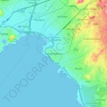
Name: Palaio Faliro topographic map, elevation, terrain.
Average elevation: 27 m
Minimum elevation: -5 m
Maximum elevation: 148 m
Make a donation
Gear up for your next adventure:
As an Amazon Associate, this site earns from qualifying purchases at no extra cost to you.
Other topographic maps
Click on a map to view its topography, its elevation and its terrain.
Municipality of Agios Dimitrios
Greece > Attica > Regional Unit of South Athens
Average elevation: 80 m