Geolocate

Linkeroever topographic map

Click on the map to display elevation.

About this map

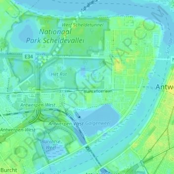
Name: Linkeroever topographic map, elevation, terrain.

Location: Linkeroever, Antwerp, Flanders, 2050, Belgium (51.20191 4.33812 51.24000 4.39802)

Average elevation: 5 m

Minimum elevation: -14 m

Maximum elevation: 16 m

Other topographic maps

Click on a map to view its topography, its elevation and its terrain.

Lillo-Fort

Belgium > Antwerp > Antwerp > Antwerp

Average elevation: 3 m

Antwerp

Belgium > Antwerp > Antwerp > Antwerp

Average elevation: 5 m

Donk

Belgium > Antwerp > Antwerp > Antwerp > Ekeren

Average elevation: 6 m

Antwerp

Belgium > Antwerp > Antwerp > Antwerp

Average elevation: 9 m

Gear up for your next adventure:

🗺️Ordnance Survey Maps - Official UK maps for walking and outdoor activities
🌄Compact Monoculars - Lightweight optics for hiking
🧣Fleece Neck Warmers - Extra insulation for winter topographic surveys
👖Convertible Hiking Trousers - Versatile zip-off pants for changing mountain weather conditions
👟Heavy Duty Boot Laces - Always carry a spare for your hiking footwear

As an Amazon Associate, this site earns from qualifying purchases at no extra cost to you.