Geolocate

Packington topographic map

Click on the map to display elevation.

About this map
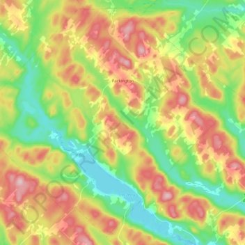
Name: Packington topographic map, elevation, terrain.

Location: Packington, Témiscouata, Bas-Saint-Laurent, Quebec, Canada (47.40377 -68.91196 47.53104 -68.71056)

Average elevation: 311 m

Minimum elevation: 202 m

Maximum elevation: 453 m

Other topographic maps

Click on a map to view its topography, its elevation and its terrain.
Saint-Éleuthère

Canada > Quebec > Témiscouata

Average elevation: 296 m

Cabano

Canada > Quebec > Témiscouata > Témiscouata-sur-le-Lac

Average elevation: 199 m

Lac Raymond

Canada > Quebec > Témiscouata > Biencourt

Average elevation: 266 m

Pied-du-Lac

Canada > Quebec > Témiscouata

Average elevation: 267 m

Lac Quenouille

Canada > Quebec > Témiscouata > Pohénégamook

Average elevation: 494 m

Gear up for your next adventure:

🔥Emergency Fire Starters - Reliable ignition tools for survival situations in damp conditions
📚UK Hiking Guidebooks - Detailed route descriptions for the Lake District, Peaks, and Highlands
🔋Lithium AA Batteries - Long-lasting power that performs well in cold mountain weather
🥄Titanium Camping Sporks - The ultimate lightweight utensil for trail meals
🥤Hiking Water Bottles - Reusable bottles for hydration on the trail

As an Amazon Associate, this site earns from qualifying purchases at no extra cost to you.