
Legnano topographic map
Interactive map
Click on the map to display elevation.
About this map
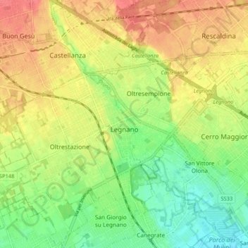
Name: Legnano topographic map, elevation, terrain.
Location: Legnano, Milan, Lombardy, 20025, Italy (45.56800 8.86561 45.62361 8.94635)
Average elevation: 210 m
Minimum elevation: 182 m
Maximum elevation: 237 m
Located in the south of the Varesine Prealps [it] along the Olona valley [it], the comune of Legnano has an area of 12.72 square kilometers (4.91 sq mi), has an elevation of 192–227 meters (630–745 ft) above sea level, and is seismically classified [it] in Zone 4 (Irrelevant seismology).
Other topographic maps
Click on a map to view its topography, its elevation and its terrain.
Lacchiarella
Lacchiarella, Milan, Lombardy, 20084, Italy
Average elevation: 95 m
Trezzo sull'Adda
Trezzo sull'Adda, Milan, Lombardy, 20056, Italy
Average elevation: 188 m
Cascina Confaloniera
Italy > Lombardy > Milan > Rosate
Cascina Confaloniera, Rosate, Unione dei Comuni I Fontanili, Milan, Lombardy, 20088, Italy
Average elevation: 107 m
Novate Milanese
Novate Milanese, Milan, Lombardy, 20026, Italy
Average elevation: 148 m
Vaiano Valle
Italy > Lombardy > Milan > Milan
Vaiano Valle, Milan, Lombardy, 20139, Italy
Average elevation: 110 m
Gorgonzola
Italy > Lombardy > Milan > Gorgonzola
Gorgonzola, Milan, Lombardy, 20064, Italy
Average elevation: 135 m
Gudo Visconti
Gudo Visconti, Unione dei Comuni I Fontanili, Milan, Lombardy, Italy
Average elevation: 113 m
Cologno Monzese
Cologno Monzese, Milan, Lombardy, 20093, Italy
Average elevation: 138 m