
Make a donation
Gear up for your next adventure:
As an Amazon Associate, this site earns from qualifying purchases at no extra cost to you.
Bogota topographic map
Click on the map to display elevation.
Make a donation
Gear up for your next adventure:
As an Amazon Associate, this site earns from qualifying purchases at no extra cost to you.
Bogota
Bogotá is located in the southeastern part of the Bogotá savanna (Sabana de Bogotá) at an average altitude of 2,640 meters (8,660 ft) above sea level. The Bogotá savanna is popularly called "savannah" (sabana), but constitutes actually a high plateau in the Andes mountains, part of an extended region known as the Altiplano Cundiboyacense, which literally means "high plateau of Cundinamarca and Boyacá". Bogotá is the largest city in the world at its elevation; there is no urban area that is both higher and more populous than Bogotá.
Make a donation
Gear up for your next adventure:
As an Amazon Associate, this site earns from qualifying purchases at no extra cost to you.
About this map
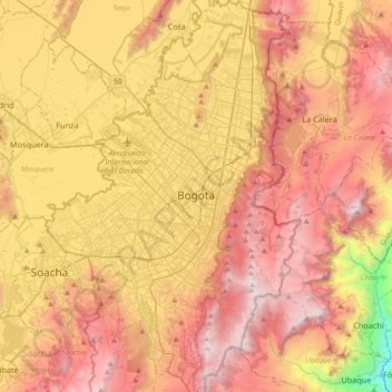
Name: Bogota topographic map, elevation, terrain.
Average elevation: 2,711 m
Minimum elevation: 1,503 m
Maximum elevation: 3,653 m
Make a donation
Gear up for your next adventure:
As an Amazon Associate, this site earns from qualifying purchases at no extra cost to you.
Other topographic maps
Click on a map to view its topography, its elevation and its terrain.
Cerro de Monserrate
Colombia > Bogota, Capital District
Both Monserrate and its neighbor Guadalupe Hill are icons of Bogota's cityscape. The hill is a tourist attraction with access by funicular or cable car (both of which charge a fee) or the pilgrimage hiking trail (free). The hiking path is 2.4 km (1.5 mi), where you can walk up the steep hill on a journey that…
Average elevation: 2,884 m