
Make a donation
Gear up for your next adventure:
As an Amazon Associate, this site earns from qualifying purchases at no extra cost to you.
Kalpetta topographic map
Click on the map to display elevation.
Make a donation
Gear up for your next adventure:
As an Amazon Associate, this site earns from qualifying purchases at no extra cost to you.
Kalpetta
Kalpetta is a major City, Town and municipality in the Wayanad district of the Indian state of Kerala. Kalpetta is the headquarters of Wayanad district, as well as the headquarters of Vythiri taluk. It is a bustling city, town surrounded by dense coffee and tea plantations and mountains. It lies on the Kozhikode-Mysore National Highway NH 766 (formerly NH 212) at an altitude of about 780 m above sea level. Kalpetta is 72 km from Kozhikode and 140 km from Mysore.
Make a donation
Gear up for your next adventure:
As an Amazon Associate, this site earns from qualifying purchases at no extra cost to you.
About this map
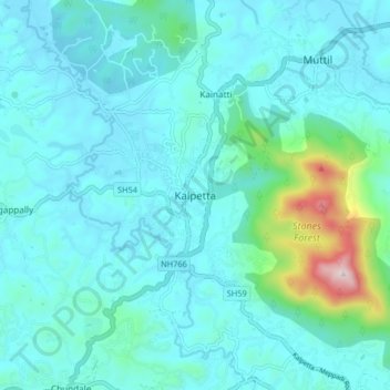
Name: Kalpetta topographic map, elevation, terrain.
Location: Kalpetta, Vythiri, Wayanad, Kerala, 673121, India (11.57028 76.04281 11.65028 76.12281)
Average elevation: 809 m
Minimum elevation: 722 m
Maximum elevation: 1,385 m
Make a donation
Gear up for your next adventure:
As an Amazon Associate, this site earns from qualifying purchases at no extra cost to you.
Other topographic maps
Click on a map to view its topography, its elevation and its terrain.