
Stia topographic map
Interactive map
Click on the map to display elevation.
About this map
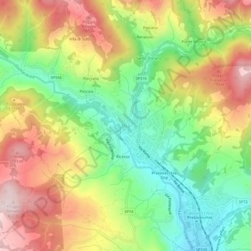
Name: Stia topographic map, elevation, terrain.
Location: Stia, Pratovecchio Stia, Arezzo, Tuscany, 52017, Italy (43.78154 11.68673 43.82154 11.72673)
Average elevation: 595 m
Minimum elevation: 402 m
Maximum elevation: 821 m
Stia grew up as the market place below the Guidi castle at Porciano. Presumably due to the topography, the piazza is not a normal square, but a more unusual triangular shape, sloping steeply at its far end. Today called Piazza Tanucci, after the Bernardo Tanucci, an Italian statesman, who was born in Stia in 1698.
Other topographic maps
Click on a map to view its topography, its elevation and its terrain.
Castiglion Fiorentino
Castiglion Fiorentino, Arezzo, Tuscany, 52043, Italy
Average elevation: 374 m
Bellavista
Italy > Tuscany > Arezzo > Ambra
Bellavista, Ambra, Bucine, Arezzo, Tuscany, 52021, Italy
Average elevation: 314 m
Borgo alla Collina
Borgo alla Collina, Castel San Niccolò, Arezzo, Tuscany, 52018, Italy
Average elevation: 436 m
Castelluccio
Castelluccio, Capolona, Arezzo, Tuscany, Italy
Average elevation: 260 m
Vetrivecchi
Italy > Tuscany > Arezzo > San Giovanni Valdarno
Vetrivecchi, San Giovanni Valdarno, Arezzo, Tuscany, 52027, Italy
Average elevation: 158 m
Loro Ciuffenna
Loro Ciuffenna, Arezzo, Tuscany, 52024, Italy
Average elevation: 602 m
Montagnano
Montagnano, Monte San Savino, Arezzo, Tuscany, 52047, Italy
Average elevation: 257 m
Pratovecchio Stia
Pratovecchio Stia, Arezzo, Tuscany, Italy
Average elevation: 856 m
Pergine Valdarno
Pergine Valdarno, Laterina Pergine Valdarno, Arezzo, Tuscany, 52020, Italy
Average elevation: 313 m
La Villa
Italy > Tuscany > Arezzo > Sansepolcro > La Montagna
La Villa, La Montagna, Sansepolcro, Arezzo, Tuscany, Italy
Average elevation: 795 m
Santa Maria
Italy > Tuscany > Arezzo > Lucignano > Santa Maria
Santa Maria, Lucignano, Arezzo, Tuscany, 52046, Italy
Average elevation: 298 m