
Make a donation
Gear up for your next adventure:
As an Amazon Associate, this site earns from qualifying purchases at no extra cost to you.
Padul topographic map
Click on the map to display elevation.
Make a donation
Gear up for your next adventure:
As an Amazon Associate, this site earns from qualifying purchases at no extra cost to you.
Padul
El Padul is a municipality of south-eastern Spain, in the province of Granada, within the comarca of el Valle de Lecrín. The population on 2008 was 8.440 inhabitants. This town is situated 13 km at the south of the city of Granada. Its altitude is 744 meters above the sea level.
Make a donation
Gear up for your next adventure:
As an Amazon Associate, this site earns from qualifying purchases at no extra cost to you.
About this map
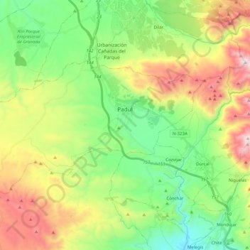
Name: Padul topographic map, elevation, terrain.
Average elevation: 964 m
Minimum elevation: 508 m
Maximum elevation: 1,754 m
Make a donation
Gear up for your next adventure:
As an Amazon Associate, this site earns from qualifying purchases at no extra cost to you.
Other topographic maps
Click on a map to view its topography, its elevation and its terrain.