
Canfranc topographic map
Interactive map
Click on the map to display elevation.
About this map
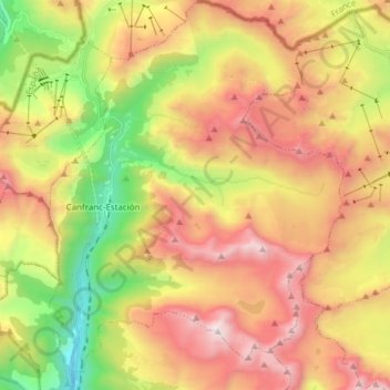
Name: Canfranc topographic map, elevation, terrain.
Location: Canfranc, Jacetania, Huesca, Aragon, 22880, Spain (42.69725 -0.53755 42.80944 -0.42112)
Average elevation: 1,862 m
Minimum elevation: 994 m
Maximum elevation: 2,872 m
The village, which lies in the valley of the Aragón River, covers an area of 71.6 km2 (27.6 sq mi) and is situated at an altitude of 1,040 m (3,410 ft). The remains to be seen include a Romanesque pilgrim's bridge and two churches of interest: Nuestra Señora de la Asunción (12th to 16th centuries) with four baroque retablos, and La Trinidad (16th century). The town was obliterated by fire in 1617 and again in 1944, after which the villagers for the most part moved to nearby Canfranc Station. The current population is 77.
Other topographic maps
Click on a map to view its topography, its elevation and its terrain.