
Make a donation
Gear up for your next adventure:
As an Amazon Associate, this site earns from qualifying purchases at no extra cost to you.
Qazvin topographic map
Click on the map to display elevation.
Make a donation
Gear up for your next adventure:
As an Amazon Associate, this site earns from qualifying purchases at no extra cost to you.
Qazvin
Located in 150 km (93 mi) northwest of Tehran, in the Qazvin Province, it is at an altitude of about 1,800 m (5,900 ft) above sea level. Due to its position at the south of the rugged Alborz range called KTS Atabakiyam, its climate is cold but dry.
Make a donation
Gear up for your next adventure:
As an Amazon Associate, this site earns from qualifying purchases at no extra cost to you.
About this map
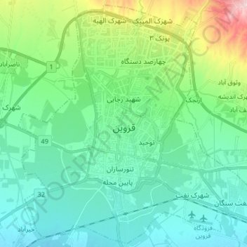
Name: Qazvin topographic map, elevation, terrain.
Location: Qazvin, مرز شهر قزوین, Qazvin County, Qazvin Province, Iran (36.23085 49.95072 36.33242 50.08118)
Average elevation: 1,324 m
Minimum elevation: 1,264 m
Maximum elevation: 1,534 m
Make a donation
Gear up for your next adventure:
As an Amazon Associate, this site earns from qualifying purchases at no extra cost to you.
Other topographic maps
Click on a map to view its topography, its elevation and its terrain.
Make a donation
Gear up for your next adventure:
As an Amazon Associate, this site earns from qualifying purchases at no extra cost to you.
Make a donation
Gear up for your next adventure:
As an Amazon Associate, this site earns from qualifying purchases at no extra cost to you.
Vanash Pain
Iran > Qazvin Province > Qazvin County > دهستان الموت پائین > Vanash Pain
Average elevation: 2,402 m