
Make a donation
Gear up for your next adventure:
As an Amazon Associate, this site earns from qualifying purchases at no extra cost to you.
Busby topographic map
Click on the map to display elevation.
Make a donation
Gear up for your next adventure:
As an Amazon Associate, this site earns from qualifying purchases at no extra cost to you.
About this map
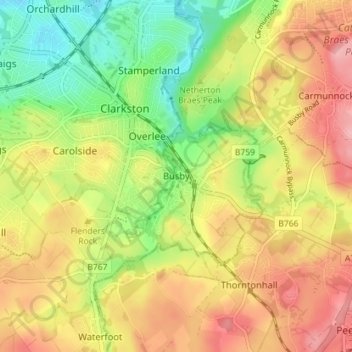
Name: Busby topographic map, elevation, terrain.
Location: Busby, East Renfrewshire, Scotland, G76 8JZ, United Kingdom (55.76157 -4.28581 55.80157 -4.24581)
Average elevation: 104 m
Minimum elevation: 42 m
Maximum elevation: 163 m
East Renfrewshire trails, hiking, mountain biking, running and outdoor activities
Make a donation
Gear up for your next adventure:
As an Amazon Associate, this site earns from qualifying purchases at no extra cost to you.
Other topographic maps
Click on a map to view its topography, its elevation and its terrain.
Dams to Darnley Country Park
United Kingdom > Scotland > East Renfrewshire > Barrhead
Average elevation: 77 m