
Make a donation
Gear up for your next adventure:
As an Amazon Associate, this site earns from qualifying purchases at no extra cost to you.
Roodt topographic map
Click on the map to display elevation.
Make a donation
Gear up for your next adventure:
As an Amazon Associate, this site earns from qualifying purchases at no extra cost to you.
Roodt
Roodt (Luxembourgish: Rued) is a small town in the commune of Ell, in western Luxembourg. As of 2005, the town has a population of 150. Longitude : 5.82 Latitude : 49.79 Altitude : 428m
Make a donation
Gear up for your next adventure:
As an Amazon Associate, this site earns from qualifying purchases at no extra cost to you.
About this map
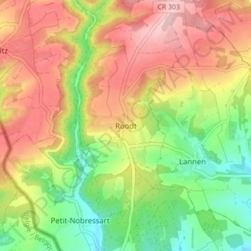
Name: Roodt topographic map, elevation, terrain.
Location: Roodt, Ell, Canton Redange, 8560, Luxembourg (49.77424 5.80175 49.81424 5.84175)
Average elevation: 412 m
Minimum elevation: 311 m
Maximum elevation: 514 m
Make a donation
Gear up for your next adventure:
As an Amazon Associate, this site earns from qualifying purchases at no extra cost to you.
Other topographic maps
Click on a map to view its topography, its elevation and its terrain.