
Hanle topographic map
Click on the map to display elevation.
About this map
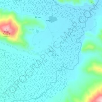
Name: Hanle topographic map, elevation, terrain.
Location: Hanle, Leh Tehsil, Leh District, Ladakh, India (32.75148 78.96321 32.79148 79.00321)
Average elevation: 4,287 m
Minimum elevation: 4,249 m
Maximum elevation: 4,517 m
Other topographic maps
Click on a map to view its topography, its elevation and its terrain.
Indus
India > Ladakh > Leh Tehsil
In the uppermost, highest part of the Indus River basin there are relatively few genera and species: Diptychus, Ptychobarbus, Schizopyge, Schizopygopsis and Schizothorax snowtrout, Triplophysa loaches, and the catfish Glyptosternon reticulatum. Going downstream these are soon joined by the golden mahseer Tor…
Average elevation: 4,192 m