
Vivès topographic map
Interactive map
Click on the map to display elevation.
About this map
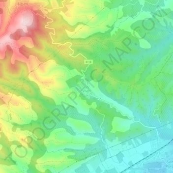
Name: Vivès topographic map, elevation, terrain.
Average elevation: 213 m
Minimum elevation: 94 m
Maximum elevation: 422 m
Other topographic maps
Click on a map to view its topography, its elevation and its terrain.
Osséja
France > Occitania > Pyrénées-Orientales
Osséja, Prades, Pyrénées-Orientales, Occitania, Metropolitan France, 66340, France
Average elevation: 1,562 m
Torreilles
France > Occitania > Pyrénées-Orientales
Torreilles, Perpignan, Pyrénées-Orientales, Occitania, Metropolitan France, 66440, France
Average elevation: 4 m
Mont-Louis
France > Occitania > Pyrénées-Orientales
Mont-Louis, Prades, Pyrénées-Orientales, Occitania, Metropolitan France, 66210, France
Average elevation: 1,573 m
Pas de l'Échelle
France > Occitania > Pyrénées-Orientales > Vingrau
Pas de l'Échelle, Vingrau, Perpignan, Pyrénées-Orientales, Occitania, Metropolitan France, 66600, France
Average elevation: 267 m
Via
France > Occitania > Pyrénées-Orientales > Font-Romeu-Odeillo-Via
Via, Font-Romeu-Odeillo-Via, Prades, Pyrénées-Orientales, Occitania, Metropolitan France, 66120, France
Average elevation: 1,551 m
Montferrer
France > Occitania > Pyrénées-Orientales
Montferrer, Céret, Pyrénées-Orientales, Occitania, Metropolitan France, 66150, France
Average elevation: 809 m
Saint-Marsal
France > Occitania > Pyrénées-Orientales
Saint-Marsal, Céret, Pyrénées-Orientales, Occitania, Metropolitan France, 66110, France
Average elevation: 705 m
Saint-Laurent-de-Cerdans
France > Occitania > Pyrénées-Orientales
Saint-Laurent-de-Cerdans, Céret, Pyrénées-Orientales, Occitania, Metropolitan France, 66260, France
Average elevation: 825 m
Arles-sur-Tech
France > Occitania > Pyrénées-Orientales
Arles-sur-Tech, Céret, Pyrénées-Orientales, Occitania, Metropolitan France, 66150, France
Average elevation: 615 m
Millas
France > Occitania > Pyrénées-Orientales
Millas, Prades, Pyrénées-Orientales, Occitania, Metropolitan France, 66170, France
Average elevation: 143 m
Amélie-les-Bains-Palalda
France > Occitania > Pyrénées-Orientales
Amélie-les-Bains-Palalda, Céret, Pyrénées-Orientales, Occitania, Metropolitan France, 66110, France
Average elevation: 663 m
La Ville
France > Occitania > Pyrénées-Orientales > Saint-Laurent-de-la-Salanque
La Ville, Saint-Laurent-de-la-Salanque, Perpignan, Pyrénées-Orientales, Occitania, Metropolitan France, 66250, France
Average elevation: 4 m
Font-Romeu-Odeillo-Via
France > Occitania > Pyrénées-Orientales
Font-Romeu-Odeillo-Via, Prades, Pyrénées-Orientales, Occitania, Metropolitan France, 66120, France
Average elevation: 1,733 m
Cabestany
France > Occitania > Pyrénées-Orientales
Cabestany, Perpignan, Pyrénées-Orientales, Occitania, Metropolitan France, 66330, France
Average elevation: 29 m
Bolquère
France > Occitania > Pyrénées-Orientales
Bolquère, Prades, Pyrénées-Orientales, Occitania, Metropolitan France, 66210, France
Average elevation: 1,712 m
kiezelstrand, waterschoenen zijn geen overbodige luxe. Verder kan er meerdere malen per week een flinke wind staan.
France > Occitania > Pyrénées-Orientales > Argelès-sur-Mer
kiezelstrand, waterschoenen zijn geen overbodige luxe. Verder kan er meerdere malen per week een flinke wind staan., Argelès-Plage, Argelès-sur-Mer, Céret, Pyrénées-Orientales, Occitania, Metropolitan France, 66700, France
Average elevation: 2 m
Perpignan
France > Occitania > Pyrénées-Orientales
Perpignan, Pyrénées-Orientales, Occitania, Metropolitan France, France
Average elevation: 38 m
Villefranche-de-Conflent
France > Occitania > Pyrénées-Orientales
Villefranche-de-Conflent, Prades, Pyrénées-Orientales, Occitania, Metropolitan France, 66500, France
Average elevation: 707 m
Argelès-sur-Mer
France > Occitania > Pyrénées-Orientales
Argelès-sur-Mer, Céret, Pyrénées-Orientales, Occitania, Metropolitan France, 66700, France
Average elevation: 205 m
Banyuls-sur-Mer
France > Occitania > Pyrénées-Orientales
Banyuls-sur-Mer, Céret, Pyrénées-Orientales, Occitania, Metropolitan France, 66650, France
Average elevation: 157 m
Le Tech
France > Occitania > Pyrénées-Orientales
Le Tech, Céret, Pyrénées-Orientales, Occitania, Metropolitan France, 66230, France
Average elevation: 1,031 m
Castelnou
France > Occitania > Pyrénées-Orientales
Castelnou, Céret, Pyrénées-Orientales, Occitania, Metropolitan France, 66300, France
Average elevation: 250 m
Eyne
France > Occitania > Pyrénées-Orientales
Eyne, Prades, Pyrénées-Orientales, Occitania, Metropolitan France, 66800, France
Average elevation: 1,805 m
Vernet-les-Bains
France > Occitania > Pyrénées-Orientales
Vernet-les-Bains, Prades, Pyrénées-Orientales, Occitania, Metropolitan France, 66820, France
Average elevation: 1,037 m
Valcebollère
France > Occitania > Pyrénées-Orientales
Valcebollère, Prades, Pyrénées-Orientales, Occitania, Metropolitan France, 66340, France
Average elevation: 1,957 m
Ille-sur-Têt
France > Occitania > Pyrénées-Orientales
Ille-sur-Têt, Prades, Pyrénées-Orientales, Occitania, Metropolitan France, 66130, France
Average elevation: 240 m
Égat
France > Occitania > Pyrénées-Orientales
Égat, Prades, Pyrénées-Orientales, Occitania, Metropolitan France, 66120, France
Average elevation: 1,689 m
Targasonne
France > Occitania > Pyrénées-Orientales
Targasonne, Prades, Pyrénées-Orientales, Occitania, Metropolitan France, 66120, France
Average elevation: 1,727 m
Porté-Puymorens
France > Occitania > Pyrénées-Orientales
Porté-Puymorens, Prades, Pyrénées-Orientales, Occitania, Metropolitan France, 66760, France
Average elevation: 2,142 m
Prats-de-Mollo-la-Preste
France > Occitania > Pyrénées-Orientales
Prats-de-Mollo-la-Preste, Céret, Pyrénées-Orientales, Occitania, Metropolitan France, 66230, France
Average elevation: 1,295 m