
Sainte-Agathe-des-Monts topographic map
Interactive map
Click on the map to display elevation.
About this map
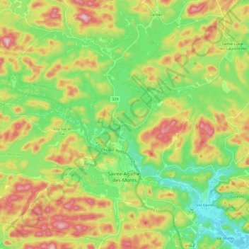
Name: Sainte-Agathe-des-Monts topographic map, elevation, terrain.
Average elevation: 418 m
Minimum elevation: 303 m
Maximum elevation: 589 m
Other topographic maps
Click on a map to view its topography, its elevation and its terrain.
Sainte-Agathe-Nord
Canada > Quebec > Sainte-Agathe-des-Monts
Sainte-Agathe-Nord, Sainte-Agathe-des-Monts, Les Laurentides, Laurentides, Quebec, J8C 0M4, Canada
Average elevation: 387 m