
Make a donation
Gear up for your next adventure:
As an Amazon Associate, this site earns from qualifying purchases at no extra cost to you.
Millinocket topographic map
Click on the map to display elevation.
Make a donation
Gear up for your next adventure:
As an Amazon Associate, this site earns from qualifying purchases at no extra cost to you.
Millinocket
The town is crossed by State Route 11 and State Route 157. The town of East Millinocket is 8 miles (13 km) to the east. Millinocket is the closest town to Mount Katahdin, in Baxter State Park, 20 miles (32 km) to the northwest. At an elevation of 5,270 feet (1,610 m), its summit is the highest point in Maine and the northern terminus of the Appalachian Trail.
Make a donation
Gear up for your next adventure:
As an Amazon Associate, this site earns from qualifying purchases at no extra cost to you.
About this map
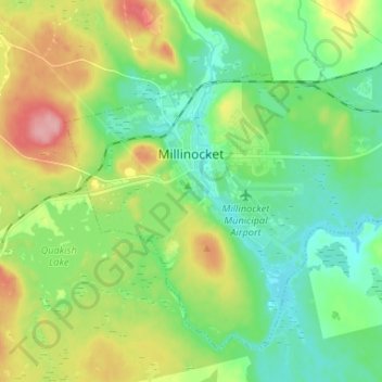
Name: Millinocket topographic map, elevation, terrain.
Location: Millinocket, Penobscot County, Maine, 04462, United States (45.61065 -68.75326 45.68671 -68.62147)
Average elevation: 140 m
Minimum elevation: 100 m
Maximum elevation: 218 m
Make a donation
Gear up for your next adventure:
As an Amazon Associate, this site earns from qualifying purchases at no extra cost to you.
Other topographic maps
Click on a map to view its topography, its elevation and its terrain.
Make a donation
Gear up for your next adventure:
As an Amazon Associate, this site earns from qualifying purchases at no extra cost to you.
Make a donation
Gear up for your next adventure:
As an Amazon Associate, this site earns from qualifying purchases at no extra cost to you.