
Thank you for supporting this site ❤️
Make a donation
Make a donation
Gear up for your next adventure:
As an Amazon Associate, this site earns from qualifying purchases at no extra cost to you.
Slawi topographic map
Click on the map to display elevation.
Thank you for supporting this site ❤️
Make a donation
Make a donation
Gear up for your next adventure:
As an Amazon Associate, this site earns from qualifying purchases at no extra cost to you.
About this map
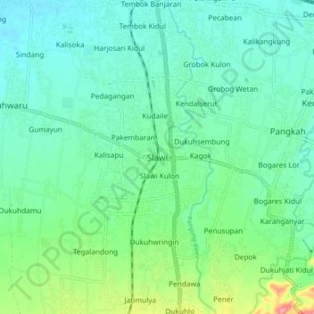
Name: Slawi topographic map, elevation, terrain.
Location: Slawi, Tegal, Central Java, Java, 52419, Indonesia (-7.02291 109.09637 -6.94291 109.17637)
Average elevation: 41 m
Minimum elevation: 13 m
Maximum elevation: 131 m
Thank you for supporting this site ❤️
Make a donation
Make a donation
Gear up for your next adventure:
As an Amazon Associate, this site earns from qualifying purchases at no extra cost to you.