
Waupun topographic map
Interactive map
Click on the map to display elevation.
About this map
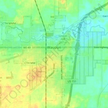
Name: Waupun topographic map, elevation, terrain.
Location: Waupun, Fond du Lac County, Wisconsin, 53963, United States (43.60537 -88.76425 43.65495 -88.71339)
Average elevation: 276 m
Minimum elevation: 264 m
Maximum elevation: 290 m
The relief of the city is moderate, ranging from 870 feet (270 m) at the Rock River, to its highest elevation of 941 feet (287 m) above sea level.
Other topographic maps
Click on a map to view its topography, its elevation and its terrain.
Rosendale
United States > Wisconsin > Fond du Lac County
Rosendale, Fond du Lac County, Wisconsin, United States
Average elevation: 277 m
Fairwater
United States > Wisconsin > Fond du Lac County > Fairwater
Fairwater, Fond du Lac County, Wisconsin, 53931, United States
Average elevation: 295 m