Geolocate

Infanta topographic map

Click on the map to display elevation.

About this map

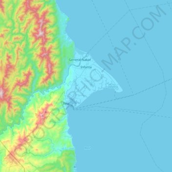
Name: Infanta topographic map, elevation, terrain.

Location: Infanta, Quezon, Calabarzon, 4336, Philippines (14.53426 121.43761 14.87463 121.83551)

Average elevation: 162 m

Minimum elevation: -1 m

Maximum elevation: 1,201 m

Other topographic maps

Click on a map to view its topography, its elevation and its terrain.

Kalilayan Ilaya

Philippines > Quezon

Average elevation: 11 m

Mount Kodiapi

Philippines > Quezon

Average elevation: 273 m

Mount Malabito

Philippines > Quezon > General Nakar

Average elevation: 963 m

Mount Binangonan

Philippines > Quezon > Infanta

Average elevation: 733 m

Mount Labo

Philippines > Quezon > Tagkawayan

Labo is a forested andesitic stratovolcano, surrounded by numerous andesitic to dacitic satellite lava domes. It has an elevation of 1,544 metres (5,066 ft) asl. Base diameter of this complex volcano is 35 kilometres (22 mi). Labo is thermally active with both warm and hot springs.

Average elevation: 1,052 m

Pury

Philippines > Quezon > San Antonio

Average elevation: 49 m

Buenavista

Philippines > Quezon

Average elevation: 66 m

Bañadero

Philippines > Quezon > Polillo

Average elevation: 13 m

Mauban

Philippines > Quezon > Mauban

Average elevation: 43 m

Mulanay

Philippines > Quezon

Average elevation: 62 m

Bucao

Philippines > Quezon > Bucao

Average elevation: 5 m

Pitogo

Philippines > Quezon > Pitogo

Average elevation: 9 m

San Juan

Philippines > Quezon > Tiaong > San Juan

Average elevation: 31 m

Minanga

Philippines > Quezon > General Nakar > Minanga

Average elevation: 512 m

Cagsiay II

Philippines > Quezon > Cagsiay II

Average elevation: 83 m

Isabang

Philippines > Quezon > Isabang

Average elevation: 135 m

Real

Philippines > Quezon > Real > Real

Average elevation: 129 m

Llavac

Philippines > Quezon > Real > Llavac

Average elevation: 367 m

Isabang River

Philippines > Quezon > Calumpang

Average elevation: 172 m

Gear up for your next adventure:

🧣Neck Gaiters - Protects against wind and sun on exposed ridges and peaks
🗺️Topographic Maps - Detailed maps showing elevation and terrain features
🧴Sport Sunscreen Sticks - High-protection sunblock that won't run into your eyes on the trail
🥤Hydration Bladders - Hands-free hydration systems for backpacks
🔦LED Camping Lanterns - Illumination for reading maps inside your tent at night

As an Amazon Associate, this site earns from qualifying purchases at no extra cost to you.