
Make a donation
Gear up for your next adventure:
As an Amazon Associate, this site earns from qualifying purchases at no extra cost to you.
New Castle topographic map
Click on the map to display elevation.
Gear up for your next adventure:
As an Amazon Associate, this site earns from qualifying purchases at no extra cost to you.
About this map
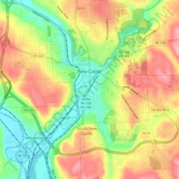
Name: New Castle topographic map, elevation, terrain.
Location: New Castle, Lawrence County, Pennsylvania, United States (40.95790 -80.39741 41.02770 -80.31530)
Average elevation: 296 m
Minimum elevation: 231 m
Maximum elevation: 367 m
Make a donation
Gear up for your next adventure:
As an Amazon Associate, this site earns from qualifying purchases at no extra cost to you.
Other topographic maps
Click on a map to view its topography, its elevation and its terrain.
North Edinburg
United States > Pennsylvania > Lawrence County > Mahoning Township
Average elevation: 279 m
West Pittsburg
United States > Pennsylvania > Lawrence County > Taylor Township
Average elevation: 279 m
West Pittsburg
United States > Pennsylvania > Lawrence County > Taylor Township
Average elevation: 279 m
Make a donation
Gear up for your next adventure:
As an Amazon Associate, this site earns from qualifying purchases at no extra cost to you.
Lower East Side
United States > Pennsylvania > Lawrence County > New Castle > Lower East Side
Average elevation: 293 m