
Gear up for your next adventure:
As an Amazon Associate, this site earns from qualifying purchases at no extra cost to you.
Make a donation
Nathia Gali topographic map
Click on the map to display elevation.
Gear up for your next adventure:
As an Amazon Associate, this site earns from qualifying purchases at no extra cost to you.
Gear up for your next adventure:
As an Amazon Associate, this site earns from qualifying purchases at no extra cost to you.
Make a donation
About this map
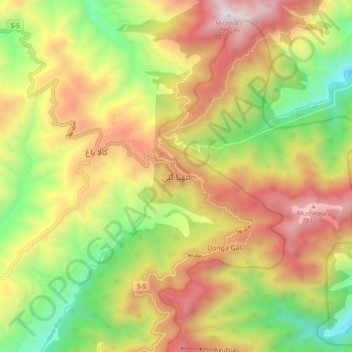
Name: Nathia Gali topographic map, elevation, terrain.
Average elevation: 2,137 m
Minimum elevation: 1,369 m
Maximum elevation: 2,959 m
Gear up for your next adventure:
As an Amazon Associate, this site earns from qualifying purchases at no extra cost to you.
Make a donation
Other topographic maps
Click on a map to view its topography, its elevation and its terrain.
Lora Tehsil
Pakistan > Khyber Pakhtunkhwa > Abbottābād District
Lora is located at an altitude of 1148 metres (3769 feet). It is situated in the southern part of Abbottabad District formerly part of Havelian Tehsil, it is now the headquarters of Lora Tehsil. It is bounded by the following union councils, Nara to the north, Nagri Totial to the north and east, Goreeni to the…
Average elevation: 1,359 m