
Make a donation
Gear up for your next adventure:
As an Amazon Associate, this site earns from qualifying purchases at no extra cost to you.
Fairfield topographic map
Click on the map to display elevation.
Make a donation
Gear up for your next adventure:
As an Amazon Associate, this site earns from qualifying purchases at no extra cost to you.
About this map
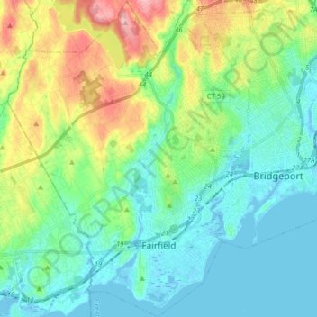
Name: Fairfield topographic map, elevation, terrain.
Average elevation: 37 m
Minimum elevation: -8 m
Maximum elevation: 138 m
Make a donation
Gear up for your next adventure:
As an Amazon Associate, this site earns from qualifying purchases at no extra cost to you.
Other topographic maps
Click on a map to view its topography, its elevation and its terrain.
Oronoque
United States > Connecticut > Greater Bridgeport Planning Region > Stratford
Average elevation: 37 m
Southport
United States > Connecticut > Greater Bridgeport Planning Region > Fairfield
Average elevation: 11 m
Greenfield Hill
United States > Connecticut > Greater Bridgeport Planning Region > Fairfield
Average elevation: 53 m
Long Hill
United States > Connecticut > Greater Bridgeport Planning Region > Trumbull
Average elevation: 117 m
Make a donation
Gear up for your next adventure:
As an Amazon Associate, this site earns from qualifying purchases at no extra cost to you.
Barn Hill
United States > Connecticut > Greater Bridgeport Planning Region > Monroe
Average elevation: 146 m
Long Hill
United States > Connecticut > Greater Bridgeport Planning Region > Trumbull
Average elevation: 117 m
Powells Hill
United States > Connecticut > Greater Bridgeport Planning Region > Easton
Average elevation: 87 m
Stratfield
United States > Connecticut > Greater Bridgeport Planning Region > Fairfield
Average elevation: 53 m
Make a donation
Gear up for your next adventure:
As an Amazon Associate, this site earns from qualifying purchases at no extra cost to you.
Lordship Beach
United States > Connecticut > Greater Bridgeport Planning Region > Stratford > Lordship
Average elevation: 1 m