
Sanbornton topographic map
Interactive map
Click on the map to display elevation.
About this map
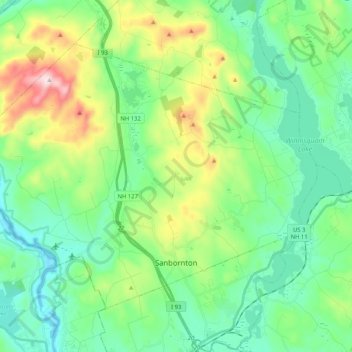
Name: Sanbornton topographic map, elevation, terrain.
Average elevation: 228 m
Minimum elevation: 91 m
Maximum elevation: 599 m
According to the United States Census Bureau, the town has a total area of 49.7 square miles (128.6 km2), of which 47.4 sq mi (122.7 km2) are land and 2.3 sq mi (5.9 km2) are water, comprising 4.58% of the town. Bounded on the west by the Pemigewasset River and on the east by Lake Winnisquam, Sanbornton is largely drained by Salmon Brook, a tributary of the Pemigewasset. The highest point in town is the summit of Hersey Mountain, elevation 2,001 feet (610 m) above sea level, along the town's northwestern border.
Other topographic maps
Click on a map to view its topography, its elevation and its terrain.
Lake Winnipesaukee
United States > New Hampshire > Belknap County > Alton
Lake Winnipesaukee, Alton, Belknap County, New Hampshire, 03226, United States
Average elevation: 223 m
The Plains
United States > New Hampshire > Belknap County > Tilton
The Plains, Tilton, Belknap County, New Hampshire, 03252, United States
Average elevation: 167 m
Mallard Cove
United States > New Hampshire > Belknap County > Laconia
Mallard Cove, Laconia, Belknap County, New Hampshire, 03246, United States
Average elevation: 173 m
Gilford
United States > New Hampshire > Belknap County
Gilford, Belknap County, New Hampshire, 03249, United States
Average elevation: 231 m
Tilton
United States > New Hampshire > Belknap County
Tilton, Belknap County, New Hampshire, United States
Average elevation: 196 m
Meredith
United States > New Hampshire > Belknap County
Meredith, Belknap County, New Hampshire, 03253, United States
Average elevation: 215 m
Barnstead
United States > New Hampshire > Belknap County
Barnstead, Belknap County, New Hampshire, United States
Average elevation: 221 m