
Sankt Wendel topographic map
Interactive map
Click on the map to display elevation.
About this map
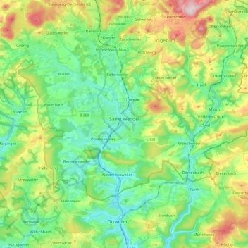
Name: Sankt Wendel topographic map, elevation, terrain.
Location: Sankt Wendel, Landkreis St. Wendel, Saarland, 66606, Germany (49.41609 7.06774 49.51141 7.30564)
Average elevation: 359 m
Minimum elevation: 252 m
Maximum elevation: 589 m
St. Wendel is situated on the river Blies west of the Bosenberg hill at an elevation of 938 feet (286 m). Its highest elevation is the Bosenberg hill at 1591 feet (485 m); the lowest is where the river Blies exits St. Wendel heading for Ottweiler at 853 feet (260 m).
Other topographic maps
Click on a map to view its topography, its elevation and its terrain.
Nohfelden
Germany > Saarland > Landkreis St. Wendel
Nohfelden, Landkreis St. Wendel, Saarland, 66625, Germany
Average elevation: 432 m
Nonnweiler
Germany > Saarland > Landkreis St. Wendel
Nonnweiler, Landkreis St. Wendel, Saarland, 66620, Germany
Average elevation: 424 m
Bostalsee
Germany > Saarland > Landkreis St. Wendel > Nohfelden
Bostalsee, Gonnesweiler, Nohfelden, Landkreis St. Wendel, Saarland, Germany
Average elevation: 412 m