
Make a donation
Gear up for your next adventure:
As an Amazon Associate, this site earns from qualifying purchases at no extra cost to you.
Cimarron topographic map
Click on the map to display elevation.
Make a donation
Gear up for your next adventure:
As an Amazon Associate, this site earns from qualifying purchases at no extra cost to you.
About this map
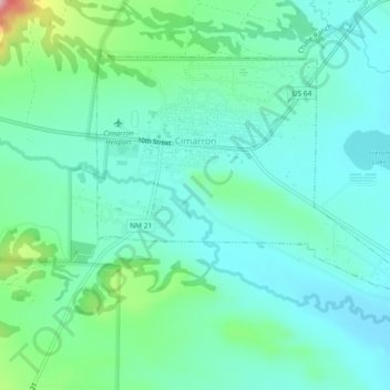
Name: Cimarron topographic map, elevation, terrain.
Location: Cimarron, Colfax County, New Mexico, 87714, United States (36.49249 -104.92732 36.51909 -104.88115)
Average elevation: 1,976 m
Minimum elevation: 1,934 m
Maximum elevation: 2,128 m
Make a donation
Gear up for your next adventure:
As an Amazon Associate, this site earns from qualifying purchases at no extra cost to you.
Other topographic maps
Click on a map to view its topography, its elevation and its terrain.
Make a donation
Gear up for your next adventure:
As an Amazon Associate, this site earns from qualifying purchases at no extra cost to you.
Apache Spring
United States > New Mexico > Colfax County > Val Verde Ski Area
Average elevation: 2,966 m