Geolocate

Arkadelphia topographic map

Click on the map to display elevation.

About this map

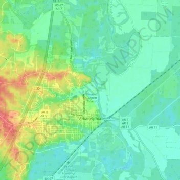
Name: Arkadelphia topographic map, elevation, terrain.

Location: Arkadelphia, Clark County, Arkansas, United States (34.09195 -93.11125 34.17666 -93.04144)

Average elevation: 67 m

Minimum elevation: 46 m

Maximum elevation: 121 m

Other topographic maps

Click on a map to view its topography, its elevation and its terrain.

Barringer

United States > Arkansas > Clark County

Average elevation: 75 m

Ozark Plateau

United States > Arkansas > Clark County

Average elevation: 51 m

Gear up for your next adventure:

🔋Solar Power Banks - Keep your GPS and phone charged during multi-day expeditions
🔋Power Banks - Portable chargers for long outdoor trips
📚UK Hiking Guidebooks - Detailed route descriptions for the Lake District, Peaks, and Highlands
🧺Ultralight Dry Bags - Organize and waterproof your gear inside your rucksack
🎒Multi-day Trekking Packs - Large capacity backpacks for wild camping and long-distance trails

As an Amazon Associate, this site earns from qualifying purchases at no extra cost to you.