
Thank you for supporting this site ❤️
Make a donation
Make a donation
Gear up for your next adventure:
As an Amazon Associate, this site earns from qualifying purchases at no extra cost to you.
Lajas topographic map
Click on the map to display elevation.
Thank you for supporting this site ❤️
Make a donation
Make a donation
Gear up for your next adventure:
As an Amazon Associate, this site earns from qualifying purchases at no extra cost to you.
About this map
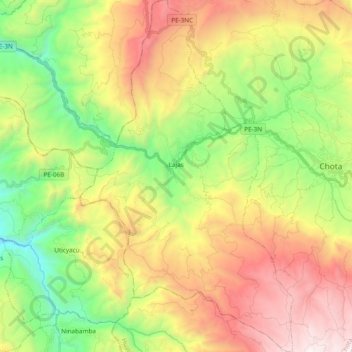
Name: Lajas topographic map, elevation, terrain.
Location: Lajas, Province of Chota, Cajamarca, Peru (-6.66141 -78.78667 -6.47228 -78.67121)
Average elevation: 2,588 m
Minimum elevation: 1,699 m
Maximum elevation: 3,754 m
Thank you for supporting this site ❤️
Make a donation
Make a donation
Gear up for your next adventure:
As an Amazon Associate, this site earns from qualifying purchases at no extra cost to you.