
Thank you for supporting this site ❤️
Make a donation
Make a donation
Gear up for your next adventure:
As an Amazon Associate, this site earns from qualifying purchases at no extra cost to you.
Yasuj topographic map
Click on the map to display elevation.
Thank you for supporting this site ❤️
Make a donation
Make a donation
Gear up for your next adventure:
As an Amazon Associate, this site earns from qualifying purchases at no extra cost to you.
About this map
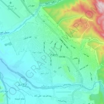
Name: Yasuj topographic map, elevation, terrain.
Average elevation: 1,860 m
Minimum elevation: 1,727 m
Maximum elevation: 2,375 m
Thank you for supporting this site ❤️
Make a donation
Make a donation
Gear up for your next adventure:
As an Amazon Associate, this site earns from qualifying purchases at no extra cost to you.
Other topographic maps
Click on a map to view its topography, its elevation and its terrain.
غضنفرخانی
Iran > Kohgiluye and Buyer Ahmad Province > Buyerahmad County > دهستان کاکان
Average elevation: 2,434 m
Abadeh
Iran > Kohgiluye and Buyer Ahmad Province > Buyerahmad County > دهستان لوداب
Average elevation: 1,548 m