Geolocate

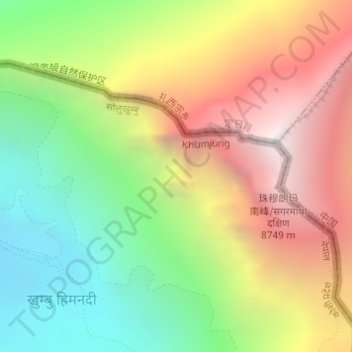
Himalayas topographic map

Click on the map to display elevation.

Himalayas

The Himalayas, or Himalaya (/ˌhɪməˈleɪ.ə, hɪˈmɑːləjə/; Sanskrit: [ɦɪmaːlɐjɐ]; from Sanskrit himá 'snow, frost', and ā-laya 'dwelling, abode'), is a mountain range in Asia, separating the plains of the Indian subcontinent from the Tibetan Plateau. The range has some of the planet's highest peaks, including the very highest, Mount Everest in Nepal. Over 100 peaks exceeding 7,200 m (23,600 ft) in elevation lie in the Himalayas. By contrast, the highest peak outside Asia (Aconcagua, in the Andes) is 6,961 m (22,838 ft) tall.

Wikipedia (CC-BY-SA 3.0)

About this map

Name: Himalayas topographic map, elevation, terrain.

Location: Himalayas, Khumbupasanglahmu, Solukhumbu, Koshi Province, Nepal (27.98564 86.91629 27.98574 86.91639)

Average elevation: 7,555 m

Minimum elevation: 6,448 m

Maximum elevation: 8,849 m

Other topographic maps

Click on a map to view its topography, its elevation and its terrain.
Khumbupasanglahmu

Nepal > Koshi Province > Solukhumbu

Average elevation: 4,909 m

Sotang

Nepal > Koshi Province > Solukhumbu

Average elevation: 2,173 m

Likhupike

Nepal > Koshi Province > Solukhumbu

Average elevation: 2,755 m

West Ridge

Nepal > Koshi Province > Solukhumbu

Average elevation: 7,035 m

Khumbupasanglahmu-05

Nepal > Koshi Province > Solukhumbu

Average elevation: 5,232 m

Gear up for your next adventure:

🧭Orienteering Compasses - Accurate compasses for map-based navigation
🚲Cycling GPS Computers - Track elevation and topographic routes on two wheels
👟Men's Trail Running Shoes - Lightweight grip for fast movement over topographic contours
🧢Hiking Hats - Sun and weather protection for outdoor walks
Insulated Travel Mugs - Keep drinks hot while surveying the landscape from a summit

As an Amazon Associate, this site earns from qualifying purchases at no extra cost to you.