
Make a donation
Gear up for your next adventure:
As an Amazon Associate, this site earns from qualifying purchases at no extra cost to you.
Bohol topographic map
Click on the map to display elevation.
Make a donation
Gear up for your next adventure:
As an Amazon Associate, this site earns from qualifying purchases at no extra cost to you.
About this map
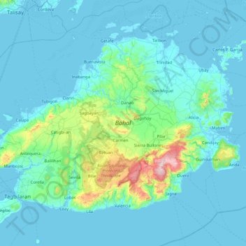
Name: Bohol topographic map, elevation, terrain.
Location: Bohol, Central Visayas, Philippines (9.58790 123.78139 10.17341 124.59735)
Average elevation: 77 m
Minimum elevation: -3 m
Maximum elevation: 853 m
Make a donation
Gear up for your next adventure:
As an Amazon Associate, this site earns from qualifying purchases at no extra cost to you.
Other topographic maps
Click on a map to view its topography, its elevation and its terrain.
Make a donation
Gear up for your next adventure:
As an Amazon Associate, this site earns from qualifying purchases at no extra cost to you.
Calape
Most of the coastal area is a fairly level plain that gradually rises into rolling hills of coralline limestone. The highest point in Calape is Mount Candungao in the eastern portion of the town, with an elevation of 150 metres (500 ft) above sea level.
Average elevation: 46 m
Make a donation
Gear up for your next adventure:
As an Amazon Associate, this site earns from qualifying purchases at no extra cost to you.
Make a donation
Gear up for your next adventure:
As an Amazon Associate, this site earns from qualifying purchases at no extra cost to you.