Geolocate

Lamu topographic map

Click on the map to display elevation.

About this map
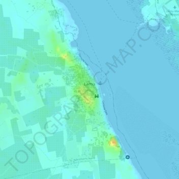
Name: Lamu topographic map, elevation, terrain.

Location: Lamu, Lamu West, Lamu, Kenya (-2.28247 40.89296 -2.25329 40.90883)

Average elevation: 4 m

Minimum elevation: 0 m

Maximum elevation: 28 m

Other topographic maps

Click on a map to view its topography, its elevation and its terrain.

Bora Imani

Kenya > Lamu > Lamu West > Hindi ward

Average elevation: 7 m

Jipe

Kenya > Lamu > Lamu West > Hindi ward

Average elevation: 10 m

Shela

Kenya > Lamu > Lamu West > Shella ward

Average elevation: 5 m

Mkunumbi

Kenya > Lamu > Lamu West > Mkunumbi ward

Average elevation: 5 m

Gear up for your next adventure:

🥄Titanium Camping Sporks - The ultimate lightweight utensil for trail meals
🧘Folding Sit Mats - Dry and warm seat for map-reading breaks on damp ground
📦Dry Bags - Waterproof bags to protect gear from rain
🧭Emergency Beacons - Safety beacons for remote outdoor locations
🚲Cycling GPS Computers - Track elevation and topographic routes on two wheels

As an Amazon Associate, this site earns from qualifying purchases at no extra cost to you.