
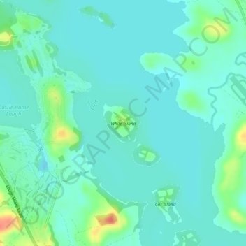
White Island topographic map
Interactive map
Click on the map to display elevation.
About this map
Name: White Island topographic map, elevation, terrain.
Average elevation: 48 m
Minimum elevation: 37 m
Maximum elevation: 86 m
Other topographic maps
Click on a map to view its topography, its elevation and its terrain.
Donagh
United Kingdom > Northern Ireland > County Fermanagh
Donagh, County Fermanagh, Northern Ireland, BT92 5BG, United Kingdom
Average elevation: 82 m
Brookeborough
United Kingdom > Northern Ireland > County Fermanagh
Brookeborough, County Fermanagh, Northern Ireland, BT94 4EZ, United Kingdom
Average elevation: 97 m
Brattan's Hill
United Kingdom > Northern Ireland > County Fermanagh
Brattan's Hill, Ardunshin, County Fermanagh, Northern Ireland, BT94 4RT, United Kingdom
Average elevation: 79 m
Lough Navar
United Kingdom > Northern Ireland > County Fermanagh
Lough Navar, Barr of Drumbadmeen, County Fermanagh, Ulster, Northern Ireland, United Kingdom
Average elevation: 232 m
Carr
United Kingdom > Northern Ireland > County Fermanagh
Carr, County Fermanagh, Northern Ireland, United Kingdom
Average elevation: 60 m
Tempo
United Kingdom > Northern Ireland > County Fermanagh > Tempo
Tempo, County Fermanagh, Northern Ireland, BT94 3LU, United Kingdom
Average elevation: 127 m
Bellanaleck
United Kingdom > Northern Ireland > County Fermanagh
Bellanaleck, County Fermanagh, Ulster, Northern Ireland, BT92 2BA, United Kingdom
Average elevation: 54 m
Irvinestown
United Kingdom > Northern Ireland > County Fermanagh
Irvinestown, County Fermanagh, Ulster, Northern Ireland, BT94 1GS, United Kingdom
Average elevation: 95 m
Belcoo
United Kingdom > Northern Ireland > County Fermanagh
Belcoo, County Fermanagh, Ulster, Northern Ireland, BT93 5FB, United Kingdom
Average elevation: 86 m
Derrygonnelly
United Kingdom > Northern Ireland > County Fermanagh
Derrygonnelly, County Fermanagh, Ulster, Northern Ireland, BT93 6HW, United Kingdom
Average elevation: 79 m