Geolocate

Keswick Ridge topographic map

Click on the map to display elevation.

About this map

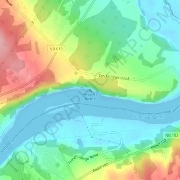
Name: Keswick Ridge topographic map, elevation, terrain.

Location: Keswick Ridge, Bright Parish, New Brunswick, E3E 1K3, Canada (45.96386 -66.84465 45.96396 -66.84455)

Average elevation: 43 m

Minimum elevation: -14 m

Maximum elevation: 132 m

Gear up for your next adventure:

👕Technical Hiking Tees - Moisture-management for high-exertion climbs
🥤Hiking Water Bottles - Reusable bottles for hydration on the trail
🧤Thermal Touchscreen Gloves - Stay warm while operating your GPS or smartphone camera
Camping Shelters - Emergency and lightweight shelters for outdoor use
🧤Hiking Gloves - Warm and durable gloves for cold-weather walks

As an Amazon Associate, this site earns from qualifying purchases at no extra cost to you.