
Make a donation
Gear up for your next adventure:
As an Amazon Associate, this site earns from qualifying purchases at no extra cost to you.
Limestone topographic map
Click on the map to display elevation.
Make a donation
Gear up for your next adventure:
As an Amazon Associate, this site earns from qualifying purchases at no extra cost to you.
About this map
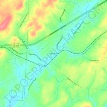
Name: Limestone topographic map, elevation, terrain.
Average elevation: 447 m
Minimum elevation: 413 m
Maximum elevation: 501 m
Make a donation
Gear up for your next adventure:
As an Amazon Associate, this site earns from qualifying purchases at no extra cost to you.
Other topographic maps
Click on a map to view its topography, its elevation and its terrain.
Johnson City
United States > Tennessee > Washington County
Johnson City occupies a broad Appalachian valley in northeastern Tennessee, where the smoother urban floor around Sinking Creek and Brush Creek sits at roughly 1,600 feet (488 meters) above sea level and is framed by progressively higher, more rugged terrain. The landscape reflects the Ridge-and-Valley…
Average elevation: 513 m
Make a donation
Gear up for your next adventure:
As an Amazon Associate, this site earns from qualifying purchases at no extra cost to you.
Johnson City
United States > Tennessee > Washington County
Johnson City occupies a broad Appalachian valley in northeastern Tennessee, where the smoother urban floor around Sinking Creek and Brush Creek sits at roughly 1,600 feet (488 meters) above sea level and is framed by progressively higher, more rugged terrain. The landscape reflects the Ridge-and-Valley…
Average elevation: 513 m