
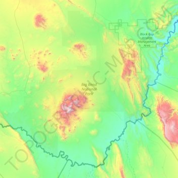
Big Bend National Park topographic map
Interactive map
Click on the map to display elevation.
About this map
Name: Big Bend National Park topographic map, elevation, terrain.
Average elevation: 934 m
Minimum elevation: 486 m
Maximum elevation: 2,330 m
Big Bend National Park is an American national park located in West Texas, bordering Mexico. The park has national significance as the largest protected area of Chihuahuan Desert topography and ecology in the United States, and was named after a large bend in the Rio Grande/Río Bravo. The park protects more than 1,200 species of plants, more than 450 species of birds, 56 species of reptiles, and 75 species of mammals. Additional park activities include scenic drives, programs led by Big Bend park rangers, and stargazing.
Other topographic maps
Click on a map to view its topography, its elevation and its terrain.
Big Bend National Park
United States > Texas > Brewster County
Big Bend National Park, Brewster County, Texas, 79834, United States
Average elevation: 934 m
Santiago Peak
United States > Texas > Brewster County
Santiago Peak, Brewster County, Texas, United States
Average elevation: 1,525 m
Alpine
United States > Texas > Brewster County
Alpine, Brewster County, Texas, United States
Average elevation: 1,373 m