
Village of East Hampton topographic map
Interactive map
Click on the map to display elevation.
About this map
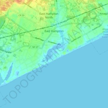
Name: Village of East Hampton topographic map, elevation, terrain.
Average elevation: 7 m
Minimum elevation: -10 m
Maximum elevation: 35 m
Other topographic maps
Click on a map to view its topography, its elevation and its terrain.
Northwest Harbor
United States > New York > Suffolk County > Town of East Hampton
Northwest Harbor, Town of East Hampton, Suffolk County, New York, 11937, United States
Average elevation: 13 m
Montauk Station
United States > New York > Suffolk County > Town of East Hampton > Montauk > Montauk Station
Montauk Station, Montauk, Town of East Hampton, Suffolk County, New York, 11954, United States
Average elevation: 11 m
Wainscott
United States > New York > Suffolk County > Town of East Hampton
Wainscott, Town of East Hampton, Suffolk County, New York, 11975, United States
Average elevation: 13 m