Geolocate

Meaford topographic map

Click on the map to display elevation.

About this map
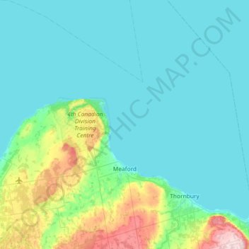
Name: Meaford topographic map, elevation, terrain.

Location: Meaford, Grey County, Southwestern Ontario, Ontario, Canada (44.47455 -80.92573 44.88494 -80.50210)

Average elevation: 222 m

Minimum elevation: 173 m

Maximum elevation: 520 m

Other topographic maps

Click on a map to view its topography, its elevation and its terrain.
The Blue Mountains

Canada > Ontario > Grey County

Average elevation: 265 m

Thornbury

Canada > Ontario > Grey County

Average elevation: 202 m

Markdale

Canada > Ontario > Grey County > Grey Highlands

Average elevation: 421 m

Gear up for your next adventure:

🧺Mesh Stuff Sacks - Breathable storage for wet gear or camp organization
🧘Folding Sit Mats - Dry and warm seat for map-reading breaks on damp ground
👖Packable Overtrousers - Quick-deploy rain protection for legs in sudden storms
🧥Softshell Jackets - Breathable jackets for active outdoor use
🎒Replacement Sternum Straps - Repair parts for hiking rucksacks

As an Amazon Associate, this site earns from qualifying purchases at no extra cost to you.