
Make a donation
Gear up for your next adventure:
As an Amazon Associate, this site earns from qualifying purchases at no extra cost to you.
Bally topographic map
Click on the map to display elevation.
Make a donation
Gear up for your next adventure:
As an Amazon Associate, this site earns from qualifying purchases at no extra cost to you.
Bally
Bally is located at 22°39′N 88°20′E / 22.65°N 88.34°E / 22.65; 88.34 and also the northernmost part of Howrah city. It has an average elevation of 15 metres (49 feet). It is more elevated in the west than the east (where flows the Hoogly river), thus leading to a problem of water logging. Bally is separated from Uttarpara, Hooghly by Bally Canal (Bally Khal) at its north. A Bridge was constructed over Bally Canal in 1846 to join the two localities.
Make a donation
Gear up for your next adventure:
As an Amazon Associate, this site earns from qualifying purchases at no extra cost to you.
About this map
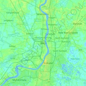
Name: Bally topographic map, elevation, terrain.
Location: Bally, Bally Jagachha, Howrah, West Bengal, 712258, India (22.48696 88.18361 22.80696 88.50361)
Average elevation: 6 m
Minimum elevation: -3 m
Maximum elevation: 23 m
Make a donation
Gear up for your next adventure:
As an Amazon Associate, this site earns from qualifying purchases at no extra cost to you.