
Make a donation
Gear up for your next adventure:
As an Amazon Associate, this site earns from qualifying purchases at no extra cost to you.
Blouberg Local Municipality topographic map
Click on the map to display elevation.
Make a donation
Gear up for your next adventure:
As an Amazon Associate, this site earns from qualifying purchases at no extra cost to you.
About this map
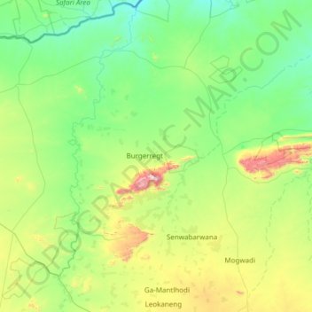
Name: Blouberg Local Municipality topographic map, elevation, terrain.
Average elevation: 887 m
Minimum elevation: 628 m
Maximum elevation: 2,032 m
Make a donation
Gear up for your next adventure:
As an Amazon Associate, this site earns from qualifying purchases at no extra cost to you.
Other topographic maps
Click on a map to view its topography, its elevation and its terrain.
Mogwadi
South Africa > Limpopo > Capricorn District Municipality > Molemole Local Municipality
Average elevation: 1,029 m
Lebowakgomo
South Africa > Limpopo > Capricorn District Municipality > Lepelle-Nkumpi Local Municipality
Average elevation: 1,017 m
Make a donation
Gear up for your next adventure:
As an Amazon Associate, this site earns from qualifying purchases at no extra cost to you.
Mankweng
South Africa > Limpopo > Capricorn District Municipality > Polokwane Local Municipality
Average elevation: 1,300 m
Ga-Molepo
South Africa > Limpopo > Capricorn District Municipality > Polokwane Local Municipality
Average elevation: 1,291 m
Make a donation
Gear up for your next adventure:
As an Amazon Associate, this site earns from qualifying purchases at no extra cost to you.
Rapitsi
South Africa > Limpopo > Capricorn District Municipality > Aganang Local Municipality
Average elevation: 1,141 m
Ga-Molepo
South Africa > Limpopo > Capricorn District Municipality > Polokwane Local Municipality
Average elevation: 1,291 m
Make a donation
Gear up for your next adventure:
As an Amazon Associate, this site earns from qualifying purchases at no extra cost to you.
Ga-Molepo
South Africa > Limpopo > Capricorn District Municipality > Polokwane Local Municipality
Average elevation: 1,291 m
Soekmekaar (Morebeng)
South Africa > Limpopo > Capricorn District Municipality > Molemole Local Municipality
Average elevation: 1,158 m
Lebowakgomo
South Africa > Limpopo > Capricorn District Municipality > Lepelle-Nkumpi Local Municipality
Average elevation: 1,017 m
Make a donation
Gear up for your next adventure:
As an Amazon Associate, this site earns from qualifying purchases at no extra cost to you.
Tooseng
South Africa > Limpopo > Capricorn District Municipality > Lepelle-Nkumpi Local Municipality
Average elevation: 812 m
Poortjie
South Africa > Limpopo > Capricorn District Municipality > Polokwane Local Municipality
Average elevation: 1,226 m
Lebowakgomo
South Africa > Limpopo > Capricorn District Municipality > Lepelle-Nkumpi Local Municipality
Average elevation: 1,017 m
Make a donation
Gear up for your next adventure:
As an Amazon Associate, this site earns from qualifying purchases at no extra cost to you.
Mogwadi
South Africa > Limpopo > Capricorn District Municipality > Molemole Local Municipality
Average elevation: 1,029 m
Make a donation
Gear up for your next adventure:
As an Amazon Associate, this site earns from qualifying purchases at no extra cost to you.
Juno
South Africa > Limpopo > Capricorn District Municipality > Aganang Local Municipality > Juno
Average elevation: 1,104 m